
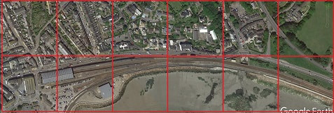
3D printed model of Penzance at 1:8000, a 1km x 1km area, centered on the station, with vertical scale exaggerated by x2.
It turns out to be extremely simple to convert UK terrain elevation data to a complete 3D printable model of a 1km x 1km square using OpenSCAD. Both the software and the elevation data are available for free download.
The full procedure is as follows:
- go to the UK Mapping data website and zoom in on the large square area of interest.
- Choose the small square you want to convert, and note its X and Y coordinates from the vertical and horizontal lines. Also note which corner of the large square it is in: NW, NE, SW or SE.
- Check to see if the LIDAR Composite Digital Surface Model (DSM) is available, and if so, choose the correct file and download it. You want one of the "DSM at 2m spatial resolution" files - hover over the download icon and see if the filename is for the correct corner of the square, ending in sw.zip, se.zip, nw.zip or ne,.zip. Coverage of England seems good; Scotland and Wales less so.
- Open the downloaded zip file and extract the correct .asc file for the area of interest. The corner and X and Y coordinates are part of the filename.
- Edit the .asc file in notepad or other text editor, deleting the header information from "ncols" up to and including the first "-9999". Then do a global search and replace, changing all remaining -9999 to 0.000 Save the result.
- Edit the 3d-terrain.scad script in OpenSCAD, and modify it to point to the data file. If the terrain is at a high elevation, you will end up with a thick pillar with the terrain on top: use your slicer to cut off the bottom if necessary. You may also want to adjust the vertical scale parameter: try different values and see what happens.
- Use the OpenSCAD buttons to render the image, generate an STL file, then copy it to your slicer.
Links (the official sites, but as always, use at your own risk):
- UK Mapping data:
https://environment.data.gov.uk/ds/survey/index.jsp#/survey - OpenSCAD:
http://www.openscad.org/downloads.html
| 3d-terrain.scad |

 RSS Feed
